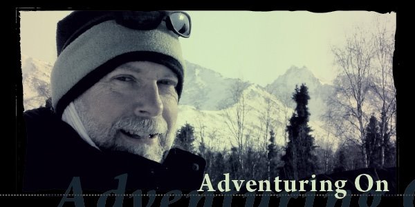


Sunday, July 6, 2014
Three 7000' Peaks in One Day
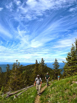
It's a good thing that I trained a bit for this hike that has been on my bucket list for quite awhile! I did this with the Inland NW Hikers and it was a fun, full day of strenuous hiking and making new friends. We first switch-backed out of the forest into sub-alpine splendor then climbed through rocks to the top of Abercrombie mountain. At 7,308 feet it is the second highest peak in Eastern Washington...by ONE FOOT! We took in the view on this sunny day as we ate our lunches. Then it was back down the trail a bit to a juncture that headed east towards our second peak. The trail gradually petered out and then we bush-whacked along a ridge then down a steep and rocky area. Gradually we made it to Hooknose Mountain at 7210' which places it comfortably at fourth place on the same list. We enjoyed a short respite then we retraced our steps. We found our way back up the east slope of Abercrombie to the trail juncture which placed us up above 7000' feet again. It really was quite a drop down then a climb back up each direction from Hooknose. One of the leaders had been skunked twice before in attempts to climb Hooknose whereas the other leader had been there many times. A beer at the parking lot, good conversation on the drive and Mexican food in Colville capped off the long day. I got home around 10pm. I am typing this the day after and I really am not looking forward to standing back up out of this chair! We hiked 12.1 miles and gained 3,218' of elevation for Abercrombie alone so I am guessing another 3000' more in addition to that.
.jpg)


 The following are some additional photos that my friend, Jim Rueckel, took on our hike. They are fantastic compared to mine!


 The following are some additional photos that my friend, Jim Rueckel, took on our hike. They are fantastic compared to mine!
Training Hike up Mt. Kit Carson
Monday, March 24, 2014
First Adventure With The Spokane Mountaineers
I have had many adventures, large and small, to catch up on but I want to get this down while it is fresh... I signed up for a two night backpack, early season trip with the Mountaineers in Hell's Canyon via Imnaha Creek in Oregon. I met my two companions at the Trading Company store on 195 and off we went with me driving. It was new territory for me as we approached the Oregon border south of Asotin, WA; always a sense of some excitement. I found the town of Joseph, Oregon delightfully located at the base of the high, snowy peaks of the Wallowa Mountains. It is a quaint, artsy locale with great potential. The mountains hang over the town with an awesomeness not unlike the Sandia Mountains hovering over Albuquerque but with the feel of, but not the ruggedness of, the Tetons.
 We proceeded to the little town of Imnaha turning north. I had no idea what was in store as the road turned to dirt with 14 miles still to go! You see, I have a problem with heights and the road was winding, single track and climbed way up; I was white-knuckling it and in full pucker mode for an eternity, it seemed. I remained tense despite the fact that the road was not too bad the rest of the way. My two passengers were nervous too as they were on the side of the shear drop off without guardrails. What was impressive about this approach drive (what little I allowed myself to observe) was the pyramidal, terraced shape of the surrounding dry peaks. They almost looked like Aztec pyramids. I wish I had some photos of them.
 At the trail head by Cow Creek Bridge there were many elaborate campsites for fisherman and this weird tent with solar panels and a strange contraption in the water next to it. A conical device was rotating in the water next to shore and we debated if it was something to capture fish with or something to measure stream flow. Really, we had no clue.
 We waited awhile for our leader, Galen, who had rented a plane and flown down to the area. When they arrived and all introductions were finished, the eleven of us headed down the trail following the fully flowing Imnaha Creek. This nice trail was constructed by the CCC in the 1930's and is a nice easy 4.2 to 5 mile trek to the confluence with the Snake River in Hell's Canyon. We arrived in the late afternoon and set up camp.


 The first night was cold but not too bad; I kept my thermal slippers over my toes and the hood of my mummy bag over my knitted cap-covered-pate! I slept deep and long and was awakened by the sound of killdeers calling over the thrumming of the Snake. I think I slept about 11 hours overall. This second day was a day of exploration and play! First the surrounding rocky outcroppings, then the ruins of the small mining outpost of Eureka and then a hike downstream as far as I could go. I stopped to draw and read with a fantastic view both up and downstream and enjoyed the morning light, the solitude and then the warmer mid morning sunshine. Some of my fellow travelers made it to the sand bar below me and I showed the three of them my spot. This was where the trail began to fade and became too steep to go on. Then back to camp over the small steam and then an exploration of the abandoned shallow mines. The one deeper mine was sealed off with a strong metal gate.


 We had a campfire that night and shared stories and, as all backpackers do, compared various opinions on equipment. The next morning we got up fairly early, broke camp, said our goodbyes at the campfire and hiked out. I saw a river otter, a gray lizard, a merganser, canyon wrens as well as a couple nice steelhead trout that some fisherman had caught. On the drives in and out we saw many mule deer and on Oregon Highway 3 we say a herd of elk and two swooping bald eagles.


 We proceeded to the little town of Imnaha turning north. I had no idea what was in store as the road turned to dirt with 14 miles still to go! You see, I have a problem with heights and the road was winding, single track and climbed way up; I was white-knuckling it and in full pucker mode for an eternity, it seemed. I remained tense despite the fact that the road was not too bad the rest of the way. My two passengers were nervous too as they were on the side of the shear drop off without guardrails. What was impressive about this approach drive (what little I allowed myself to observe) was the pyramidal, terraced shape of the surrounding dry peaks. They almost looked like Aztec pyramids. I wish I had some photos of them.
 At the trail head by Cow Creek Bridge there were many elaborate campsites for fisherman and this weird tent with solar panels and a strange contraption in the water next to it. A conical device was rotating in the water next to shore and we debated if it was something to capture fish with or something to measure stream flow. Really, we had no clue.
 We waited awhile for our leader, Galen, who had rented a plane and flown down to the area. When they arrived and all introductions were finished, the eleven of us headed down the trail following the fully flowing Imnaha Creek. This nice trail was constructed by the CCC in the 1930's and is a nice easy 4.2 to 5 mile trek to the confluence with the Snake River in Hell's Canyon. We arrived in the late afternoon and set up camp.


 The first night was cold but not too bad; I kept my thermal slippers over my toes and the hood of my mummy bag over my knitted cap-covered-pate! I slept deep and long and was awakened by the sound of killdeers calling over the thrumming of the Snake. I think I slept about 11 hours overall. This second day was a day of exploration and play! First the surrounding rocky outcroppings, then the ruins of the small mining outpost of Eureka and then a hike downstream as far as I could go. I stopped to draw and read with a fantastic view both up and downstream and enjoyed the morning light, the solitude and then the warmer mid morning sunshine. Some of my fellow travelers made it to the sand bar below me and I showed the three of them my spot. This was where the trail began to fade and became too steep to go on. Then back to camp over the small steam and then an exploration of the abandoned shallow mines. The one deeper mine was sealed off with a strong metal gate.


